Snapshot: 9 October 2026. Nothing on the page comes from a database; every moment, place and line sits in a small data file beside it (data/), with the ids of its sources.
The film
The film is drawn frame by frame from this page's own map code and data, so the film and the live map cannot disagree. Its opening, from 1750 to 1752, is drawn on Natural Earth's coastlines (public domain) in the same kilometres as the town map, so one camera runs from the Rhine to Halifax. The routes down the Rhine and the ships' tracks are approximate: the record names the rivers, the ports and the ships, not the courses.
The ships named in the film are the ones the sources name for 1750 to 1752: the Ann (from Helvoetsluys), the Speedwell (from Hamburg), the Pearl, the Gale and the Murdoch (1751; DesBrisay names the Gale and the Murdoch, and their year is from Wikipedia alone), and the Sally, the Betty and the Pearl again (1752). The fourteen transports of June 1753 are named from W. P. Bell's list as others quote it; Bell's book itself has not yet been read for this page.
The script was written from the page's fact table and approved word for word before it was spoken. The narration is a computer voice (Microsoft neural text-to-speech). The £100 fine is shown as "about $40,000 Canadian today": an estimate by prices (MeasuringWorth, £100 of 1754 is £21,313 today), at the Bank of Canada's rate of 7 October 2026. By wages the same sum would be far larger; the price figure is the low reading.
The record and its clock
Twenty-four moments, 15 December 1753 to 14 January 1754, each with its sources. The three main ones are the town's own memo of December 1753 (printed by DesBrisay in 1895), Beamish Murdoch's history (1866), which he wrote from the council minutes and Lawrence's letters, and the Dictionary of Canadian Biography.
- Two sources (a solid dot) means two independent accounts agree. DesBrisay quoting Murdoch counts as Murdoch.
- One source (a hollow dot) means only one account gives it. It is used, and marked.
- Times are shown only where a source prints them. Otherwise the record shows the part of the day the source names ("evening", "morning"). On the clock, a moment with no time sits at a nominal hour (morning 9:00, midday 12:00, evening 19:00, night 22:00); the page never shows that hour.
- Dates are Gregorian, Britain's calendar from 1752; weekdays are computed from the date.
- Quotations are only from public-domain sources (the memo, Murdoch, DesBrisay, Akins), and short.
The live map's clock runs 75 seconds. It is not even: the first eight days, 15 to 23 December, take 60% of it; the disarming, Hoffman's arrest, his voyage under guard and George's Island are squeezed into the rest, and the last part closes on the island.
Where the places are
Each place in the record carries one of three states, and is drawn by it.
- Stated: a source gives this spot for this place (Lunenburg's official name point; George's Island's coordinates).
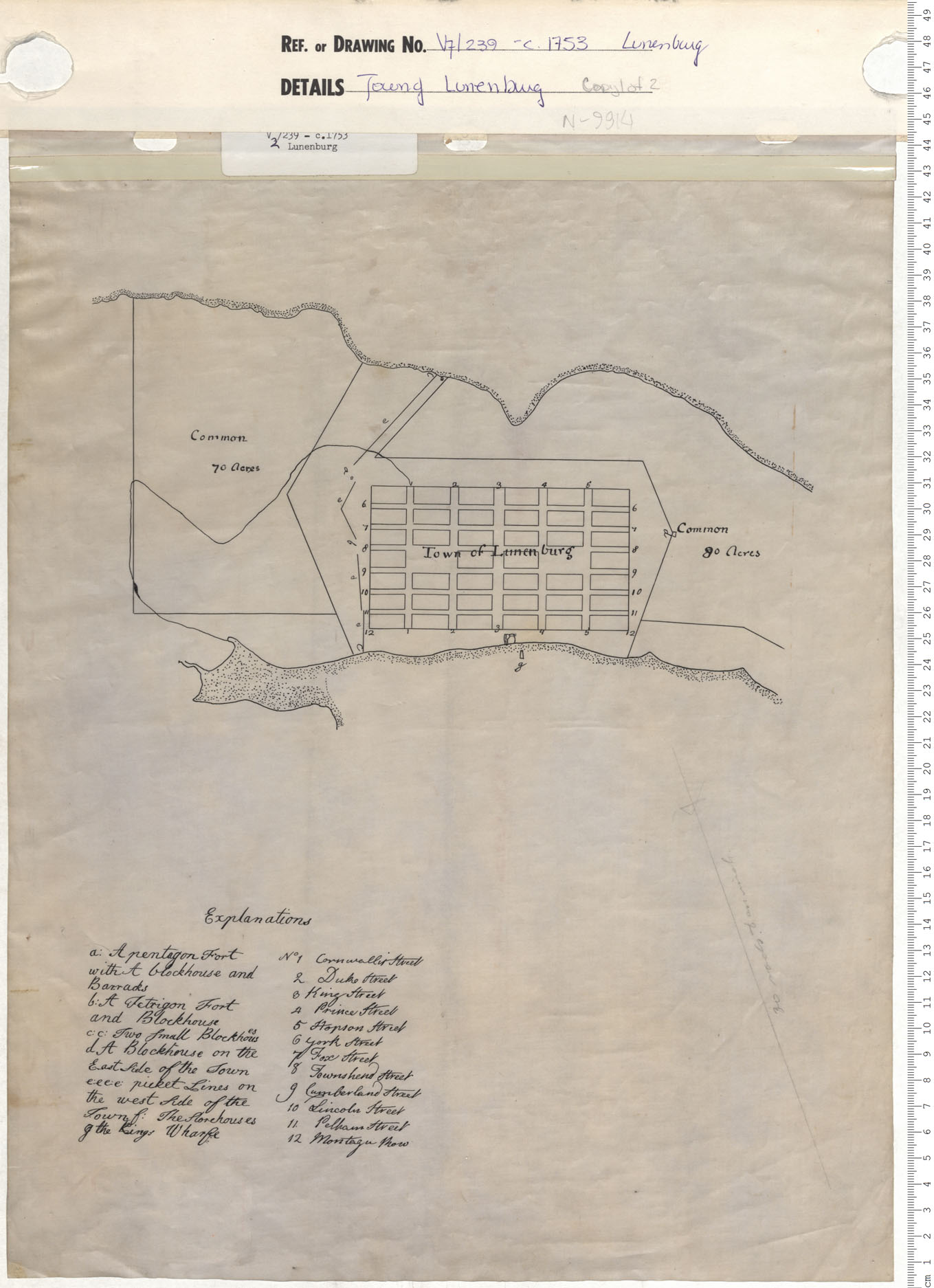
- Approximate: a source names the place and the area, and the mark sits on the nearest sourced point. Drawn with a dashed ring. The Star Fort is on the Lunenburg Academy's hill (Gallows Hill, Parks Canada), marked on the Academy's address, 97 Kaulbach St; the plan of c. 1753 puts its pentagon fort within a few metres. The block-house on Windmill Hill is on the official name point for Blockhouse Hill, and Fort Boscawen on the one for Battery Point (GeoNAMES). The parade is marked on today's Town Hall, 119 Cumberland St: the original parade square lies in the Old Town's central blocks, but which block is not stated. The storehouse is the plan's "f: The Storehouses" on the waterfront below King St; that it is the storehouse of 17 December is likely, not stated.
- Not located: no source places it, so it is listed, never drawn: the militia block-house, the West log house (the lower block-house), Harshman's house, and three of the town's block-houses.
The map
- Lunenburg's shore is today's (Nova Scotia Topographic DataBase, 1:10,000 coastline, Open Government Licence – Nova Scotia), with the later fill along the waterfront cut back to the shore drawn on the plan of c. 1753, so the plan's King's wharf runs out from the 1753 shore.
- The coast to Halifax is Statistics Canada's 2021 cartographic boundary, generalized for the screen (Open Government Licence – Canada). Halifax's shore is today's natural shore with the piers taken out and the waterfront cut back to its 1779 line (Des Barres): an approximation of the 1753 shore, not a survey.
- Streets are today's (Nova Scotia Road Network). The thirteen that DesBrisay lists for the 1753 plot are drawn heavier and named; the Old Town keeps its 1753 layout (Parks Canada). Contours are every 5 m (Nova Scotia Topographic DataBase).
- The plan of c. 1753 (Nova Scotia Archives, V7/239) was carried onto today's streets: the commons, the picket lines, the forts and block-houses, the storehouses, the King's wharf and the blocks. Positions are approximate, within tens of metres.
- Halifax in 1753 is Moses Harris's survey of 1749, carried onto today's grid; it agrees with the places the Halifax Military Heritage Preservation Society gives within 35 to 65 m. George's Island's works are schematic: the record gives sixteen guns and a palisade by 1751, not where.
- The look is a 1960s town planning plate (paper, ink, spaced capitals, one red, a title block), after the Town of Lunenburg's Urban Renewal Study of 1966. Nothing from that study is reproduced. It is an illustrative map, not a chart.
What moves on the map
- Lieutenant Adams goes to Halifax by water. How he travelled is not recorded; no road joined the two towns until the Council ordered one in 1767.
- The four vessels' track from Halifax to Lunenburg, 18 to 22 December, is not recorded. The line only keeps to open water (checked by
tools/route.mjs), and the map says it is schematic. Their muster ground, anchorage and landing place are not recorded either; they are drawing aids, labelled as such. - Figures: one soldier stands for twenty men. No source names the regiment of the two hundred; they are drawn as Monckton's own, the 47th Foot, after the Royal Clothing Warrant of 1751 and the prints of the 1740s, and their black marching gaiters are inferred. The settlers are drawn after the prints of the period. No figure is a portrait.
Pictures
- “Nachricht”, the 1750 recruiting notice: Niedersächsische Staats- und Universitätsbibliothek Göttingen, Digitalisierungszentrum (GDZ), collection Nordamericana. The work is from 1750; no licence is stated in the record, and it is shown with the library's credit.
- A plan of the Town of Lunenburg, c. 1753: Nova Scotia Archives, V7/239, shown with the Archives' credit.
- Moses Harris, the plan of the harbour of Chebucto and the town of Halifax (1750): McGill University Library, public domain. Bellin's Carte de l'Accadie (1757): public domain, via Wikimedia Commons.
- Robert Monckton: a line engraving drawn after Benjamin West's portrait (public domain). Beamish Murdoch: a line engraving drawn from his public-domain photograph. Both are made by script (
tools/engrave.py), not by hand. - The film's poster and the live map's preview are stills of this page's own map.
Where the record disagrees
- Torture: Murdoch and the Dictionary of Canadian Biography say Pettrequin was tortured; the memo of 1753 says he was bound hand and foot, and threatened. The page follows the two.
- The guard house: the West log house (Murdoch) or the lower block-house (Dictionary of Canadian Biography).
- The French: Wikipedia's article on Father Le Loutre's War ties the rising to Le Loutre. Murdoch: "There was no proof, however, that the French had instigated them." The page follows Murdoch.
- The fine: £100 (Dictionary of Canadian Biography, Akins, Cahill); Murdoch printed a blank for the amount, "a fine of —— hundred pounds". Akins: £100 or two years; the others: a fine and two years.
- The charge: seditious conspiracy (Cahill); "high crimes and misdemeanors" (Murdoch); a false and scandalous libel and inciting a riot (Dictionary of Canadian Biography).
- Why the treason bill failed: one witness to the main fact (Murdoch); a protest over state policy and corruption (Cahill, through Boudreau's review). The two reasons do not rule each other out.
- Banishment after the two years: Cahill alone, marked one source.
- Who freed Pettrequin: Sutherland and Zouberbuhler (Murdoch, the Dictionary of Canadian Biography); the memo adds Mr. Strasburg and Major Rudolf.
- Names: Pettrequin (Dictionary of Canadian Biography), Petriquin (Murdoch), Peterquin (the memo). The rising is "the Hoffman Rebellion" to Akins; this page calls it the Lunenburg Rebellion.
- The cards: the lots were drawn with cards (DesBrisay); the card he saw in court was said to be from a later drawing, of 1767.
Every source
Every source the page and the film draw on, each linked to the document. A few are behind a paywall or held only in an archive; they are marked.
The record
- "Memo. of the Rebellion", December 1753, the original Lunenburg record as printed in M. B. DesBrisay, History of the County of Lunenburg, 2nd ed. (Toronto: William Briggs, 1895), pp. 32–34
- "Memo. of Block-houses, etc., 1753", as printed in DesBrisay, History of the County of Lunenburg (1895), p. 31
- Mather Byles DesBrisay, History of the County of Lunenburg, 2nd ed. (Toronto: William Briggs, 1895)
- Beamish Murdoch, A History of Nova-Scotia, or Acadie, vol. II (Halifax: James Barnes, 1866), chapter XVII, pp. 227–230
- Thomas B. Akins, History of Halifax City (Halifax: Nova Scotia Historical Society, 1895), pp. 41–42
- Ronald Rompkey, "PETTREQUIN (Petrequin), JEAN", Dictionary of Canadian Biography, vol. 3 (University of Toronto/Université Laval, 1974)
- "ZOUBERBUHLER, SEBASTIAN", Dictionary of Canadian Biography, vol. 4
- "SUTHERLAND, PATRICK", Dictionary of Canadian Biography, vol. 3
- "MONCKTON, ROBERT", Dictionary of Canadian Biography, vol. 4
- "LAWRENCE, CHARLES", Dictionary of Canadian Biography, vol. 3
- Winthrop Pickard Bell, The Foreign Protestants and the Settlement of Nova Scotia (University of Toronto Press, 1961; reprinted Fredericton: Acadiensis Press, 1990) (an Internet Archive loan)
- Wikipedia, "Father Le Loutre's War", section on the Lunenburg Rebellion
- Barry Cahill, "The 'Hoffman Rebellion' (1753) and Hoffman's Trial (1754): Constructive High Treason and Seditious Conspiracy in Nova Scotia under the Stratocracy", in F. M. Greenwood and B. Wright (eds.), Canadian State Trials, vol. I (University of Toronto Press for the Osgoode Society, 1996), pp. 72-97 (paywalled)
- Michael Boudreau, review of Canadian State Trials vol. I, Dalhousie Law Journal 20:1 (1997), p. 275 at p. 282
- “Nachricht” (1750), the printed recruiting notice for Nova Scotia, Niedersächsische Staats- und Universitätsbibliothek Göttingen, Digitalisierungszentrum (GDZ), collection Nordamericana
- Ulrich Maier (ed.), Auf nach Neu-Schottland! Quellenmaterial für den Unterricht 22 (Landesarchivdirektion Baden-Württemberg, 2001)
- Thomas B. Akins (ed.), Selections from the Public Documents of the Province of Nova Scotia (Halifax, 1869)
- "JESSEN, DETTLIEB (Detleff), CHRISTOPHER", Dictionary of Canadian Biography, vol. 5
- "ERAD (Ehrhard), JOHANN BURGHARD", Dictionary of Canadian Biography, vol. 3
- Wikipedia, "Foreign Protestants": the years of the Gale and the Murdoch (1751), found in no other source
Maps and pictures
- Town of Lunenburg, Nova Scotia: Urban Renewal Study (1966), prepared by Canadian-British Engineering Consultants and Norman Pearson, town and country planner, with a grant from Central Mortgage and Housing Corporation; Plate 8, Town Boundaries (PDF page 86)
- Moses Harris, A Plan of the Harbour of Chebucto and Town of Halifax (the "Porcupine Map"), Gentleman's Magazine, vol. xx, July 1750, p. 295
- Thomas Jefferys, A Map of the South Part of Nova Scotia and its Fishing Banks (London, 1750), with "A Plan of Halifax Surveyed by M. Harris" and "A View of Halifax"
- J. F. W. Des Barres, King's Bay (Lunenburg), The Atlantic Neptune (1776), Library of Congress copy
- Moses Harris, 'A Plan of Halifax Survey'd by M. Harris', inset on Thomas Jefferys, A Map of the South Part of Nova Scotia and its Fishing Banks (London, 1750)
- J. F. W. Des Barres, 'Halifax Harbour. Survey'd & publish'd ... Jany. 30, 1779' (The Atlantic Neptune, pl. 20)
- French plan of Halifax, 1755 (the 'spy map'), as traced by C. Pettigrew at the Public Record Office, June 1923; Nova Scotia Archives, Beamish collection (not online)
- Jacques-Nicolas Bellin, Carte de l'Accadie et Pais Voisins (Paris, 1757), via Wikimedia Commons (scan from Paulus Swaen old maps and prints)
- Plan of the Town of Lunenburg, c. 1753, with 'Explanations' (Nova Scotia Archives, V7/239, copy 1 of 2, N-9914)
- Benjamin West, General the Hon. Robert Monckton (painted after the capture of Martinique, 1762), National Army Museum, London


.jpg)


Places today, and the map's data
- Statistics Canada, 2021 Cartographic Boundary Files, Nova Scotia
- Nova Scotia Road Network (NSRN), data.novascotia.ca dataset 484g-adjn
- Nova Scotia Topographic DataBase – Landforms (Line Layer): 5 m contours, data.novascotia.ca dataset bhx9-mpui
- GeoNAMES (Nova Scotia): official name points for Blockhouse Hill (CBRJF), Battery Point (CABZC), Lunenburg (CAWAZ), Lunenburg Harbour (CAWBB), Back Harbour (CABEC); data.novascotia.ca dataset xf3i-vxcb
- Nova Scotia Civic Address File – Civic Points: building centroids for 119 Cumberland St (Town Hall) and 97 Kaulbach St (Lunenburg Academy); data.novascotia.ca dataset tntn-er5g
- Parks Canada, Directory of Federal Heritage Designations: Lunenburg Academy National Historic Site ("atop Gallows Hill")
- Parks Canada: Old Town Lunenburg Historic District National Historic Site (1991) and "Canadian sites on the World Heritage List: Old Town Lunenburg" (inscribed 1995)
- Canadian Register of Historic Places: Lunenburg Old Town Heritage Conservation District
- Saint Mary's University: geophysical survey of Gallows Hill, Lunenburg (Fowler, report 2014); and Fraser, honours thesis (2015), which finds the anomaly's origin unknown
- Wikipedia article coordinates for Halifax, Nova Scotia and Georges Island (Nova Scotia), via the MediaWiki API
- Nova Scotia Topographic DataBase – Water Features (Line Layer), 1:10,000 coastlines, data.novascotia.ca dataset fpca-jrmt
- Halifax Military Heritage Preservation Society, 'Early Town Defences', and Tom Tulloch, 'Walking Tour of Halifax's Early Defences' (2019), after Harry Piers, The Evolution of the Halifax Fortress 1749-1928 (1947)
- Tom Tulloch, 'The Early Fortifications of Halifax' (Halifax Military Heritage Preservation Society)
- Len Canfield, 'Dartmouth's Early Years' (Halifax Military Heritage Preservation Society), after J. P. Martin, The Story of Dartmouth
- Tom Tulloch, 'To Halifax: The Arrival of the British' (Halifax Military Heritage Preservation Society)
- Leo J. Deveau, 'Early Settlement in Nova Scotia 1605-1749' (Halifax Military Heritage Preservation Society, 2019)
- Natural Earth, 1:50m coastlines, rivers and lakes (the film's Europe and Atlantic)
The film's numbers and sound
- MeasuringWorth, Purchasing Power of the British Pound (the £100 fine in today's prices)
- Bank of Canada, daily exchange rates (pound to Canadian dollar)
- musket_fire_1.wav by J8054 (freesound.org)
- musket_fire_2.wav by J8054 (freesound.org)
- musket_fire_7.wav by J8054 (freesound.org)
- waves over mall shells 01 by klankbeeld (freesound.org)
- Wood_Creak_01 by dheming (freesound.org)
- Crowd murmur at the scene of an accident by craigsmith (freesound.org)
- marching_snare_with_reverb.wav by waldschrat1510 (freesound.org)
Research notes, with every request, licence and quotation, are kept with the project and are not published. Built by Joel Hirtle, October 2026, in the shape of the Shipwrecks atlas and the Bluenose.