THE MARITIME ATLASOak Island

A TREASURE HUNT ON THE RECORD · 1795 TO 2026

Oak Island

Every famous clue of the hunt on one map, each in its year.
What was written down at the time, and what was told later.

The island on the map

THE YEAR1795
0of 29 recorded moments
Oak Island, Mahone Baybefore the story begins
60-second clock

The clock is not even: the years from 1849 to 1900, when the story was first written down, get a third of it. Every dig and drill hole in our table appears in its first year. Depths are the diggers' own, in feet.

01 · THE ISLAND ON THE MAP · 1795 TO 2026OAK ISLAND, MAHONE BAY

Charting the island…

1795 to 2026.
Hover a mark or a dig. A dashed ring means placed from a plan or a map, not surveyed.
From a record of its time From later histories Placed from a plan or map A dig or drill hole: placed, or at its site only Where diggers or the story came from Ground, every 2 m Today's shore and the 2016 bare-earth survey. Depths are as reported. Not a chart.
View

The map follows the clock: the island's east end, Nova Scotia, Mahone Bay, the whole island.

↑ BACK TO TOP

02HOW THE STORY SPREAD

A letter from Truro,
30 September 1861.

The oldest printed account of Oak Island found and read for this page is a letter signed "Patrick", dated Truro, 16 September 1861. The Nova Scotian, a Halifax newspaper, printed it on 30 September. It tells of a pit on the island that kept filling with water. A short notice in the Liverpool Transcript of August 1857 is known but was not read.

Five years later the story crossed the continent. A correspondent writing from Chester, on Mahone Bay, sent a long account to the New York Herald, printed on 2 September 1866. The Louisville Daily Democrat in Kentucky reprinted it on 13 September, the Daily Phoenix of Columbia, South Carolina, on 21 September, and the Daily British Colonist of Victoria, British Columbia, on 5 November. The Victoria copy credits the New York Times; the others credit the Herald.

The settlers told a story to go with the pit. A dying sailor, it went, said he had sailed with Captain Kidd and helped bury about two million pounds on an island. In 1883 a county map put the name on the ground: A. F. Church's map of Lunenburg County prints the words "Kidd's Treasures" on the island's east side.

The 'Patrick' letter (1861), the Louisville Daily Democrat, the Daily Phoenix and the Daily British Colonist (1866), J. B. McCully (1862) for the settlers' story, Church's map (1883). Facts f001 to f004, f019, f051 on the data page.
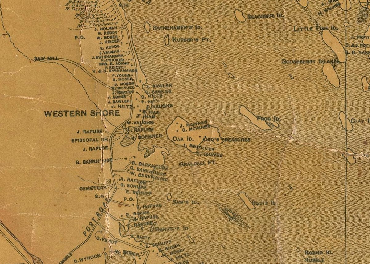
Part of an old engraved county map: Oak Island, labelled Oak Id., with owners' names on its lots and the words Kidd's Treasures printed on its east side.
Oak Island on A. F. Church's Topographical Township Map of Lunenburg County (copyright 1864, published 1883), with "Kidd's Treasures" on the east side. David Rumsey Map Collection scan, via Wikimedia Commons; public domain. Cropped.

↑ BACK TO TOP

03THE MONEY PIT

What the diggers reported,
going down.

The story says that in 1795 three young men, Smith, McGinnis and Vaughn, found a sunken spot under a great oak on the island's east end, with a tackle block hanging from a branch above it. No paper of the time records it, and the year itself first appears in print in a company prospectus of 1893.

The accounts of the 1860s and later tell what the diggers found as they went down: flagstones near the top, timber about every 10 ft (3 m), charcoal and putty, and a flat stone cut with letters or figures. At about 90 ft (27 m) the water came in. That evening a crowbar struck something hard a few feet deeper, and by morning 60 ft (18 m) of water stood in the shaft.

Where the pit was is now a matter of survey. The modern work at the pit area, Golder's borings of 1970 and Woods Hole's satellite survey of 28 July 1995, puts it on the south slope of the eastern hill, about 80 m (260 ft) from the south shore, to about 8 m (26 ft) either way. That is the area the searchers took for the Money Pit, not the shaft of 1795: Golder wrote in 1971 that the pit's exact location had been lost.

The 1862 and 1863 accounts, DesBrisay (1895), the 1893 prospectus; Golder Associates (1971); Woods Hole Oceanographic Institution (1996). Facts f018, f020, f021, f022 to f029, f053.

Down the pit, as reported. Depths in the diggers' feet; many are disputed between the accounts
DepthReportedWhen
About 2 ft (0.6 m)A tier of flagstones, thought to come from near Gold RiverThe first dig
Every 10 ft (3 m)Oak timber at 10, 20 and 30 ft; a mark every 10 ft belowThe first dig; Onslow
To about 50 ft (15 m)Charcoal, its depth not given exactly; a tier of putty at about 50 ftThe early digs
80 to 90 ft (24 to 27 m)A flat stone cut with letters or figures. One "expert" read it, by the 1893 prospectus, as two million pounds buried ten feet belowThe early digs
About 90 ft (27 m)WaterThe early digs
98 ft (30 m)"A hard impenetrable substance"; by morning, 60 ft (18 m) of waterThe early digs
Below 98 ftWood, loose metal by the sound, and three small links, which the witness says were gold1849
153 to 156 ft (47 m)A scrap of parchment about 3/8 by 1/2 inch (1 by 1.3 cm); cement in another boring1897; an account of 1906
163 ft (50 m)The Chappell shaft beside the pit1931
About 213 ft (65 m)A void, in a hole about 270 ft (82 m) north-east of the pit area1970
235 ft (72 m)Borehole 10-X, with cavities in the bedrock below 180 ft (55 m)1969

↑ BACK TO TOP

04SMITH'S COVE

Drains under the beach,
about 1850.

Smith's Cove is the east-facing beach, about 140 m (460 ft) east-north-east of the Money Pit. About 1850 the Truro Company's men found stone-built drains under the sand there, and a brown fibre like the husk of a coconut. A witness's letter of 1862 speaks of drains at the shore; the count of five drains and the name Smith's Cove first appear together in the prospectus of 1893.

In 1995 the Woods Hole Oceanographic Institution dated a coconut-type fibre dug from just below low tide in the cove. Its result, 1140 radiocarbon years before present, give or take 30, is about 1,100 years. The report says how the fibre came to be there is unclear.

In January 2018 an episode of The Curse of Oak Island showed a small lead cross with a square hole, found with a metal detector on the cove's beach. That summer the University of New Brunswick's Laser Ablation Lab analysed it and said the lead was of European origin. The lab did not give the cross an age.

McCully (1862), the 1893 prospectus, Woods Hole Oceanographic Institution (1996), the series' episode list, the University of New Brunswick (2018). The province's gazetteer puts a "Smiths Cove" name point on the south shore; this page follows the diggers' and the surveys' east beach. Facts f038 to f043.

SMITH'S COVE, SORTED

A WITNESS, 1862About 1850Drains at the shore, and coconut-like fibre
A RECORD, 18931893Five drains, at a place called Smith's Cove
A RECORD, 19961995A fibre sample dated to about 1,100 years
ON THE SHOW2018A small lead cross from the beach
A RECORD, 20182018Lead of European origin; no age given

↑ BACK TO TOP

05THE OTHER CLUES

A cave-in, a triangle,
a cross of boulders.

The Cave-in Pit. In 1878 a hole opened under an ox team between the Money Pit and Smith's Cove. It lies on a line between the pit and the drains.

The stone triangle. In 1897 Captain Welling reported a triangle of beach stones near the south shore, pointing true north, with a line from its apex that runs toward the Money Pit.

Nolan's Cross. Six large boulders in the shape of a cross, on the land of Fred Nolan, a surveyor who first came to the island in 1958. No source read for this page gives the year he found it. In 1969 Nolan drained the swamp in the middle of the island and reported part of what looked like a ship's mast.

Borehole 10-X. Triton Alliance drilled it in 1969, about 160 ft (49 m) from the Money Pit, through the bedrock to 235 ft (72 m). In 1971 Daniel Blankenship and David Tobias said a camera lowered down it recorded possible chests, human remains and tools. The images were unclear, and none of it has been confirmed independently. In 2016 a dive to the bottom found no artifacts.

Fortune (2016), the Wroclawski chronology, Wikipedia. The triangle and the cross are placed from a tourism map, to about 40 m (130 ft), and drawn with a dashed ring; the swamp is the province's topographic map. Facts f035, f036, f044 to f047, p02, p05.

THE CLUES, BY THE RECORD BEHIND THEM

1878The Cave-in Pit A LATER HISTORY, ONE SOURCE
1897The stone triangle A LATER CHRONOLOGY, ONE SOURCE
Not recordedNolan's Cross A LATER HISTORY
1969Borehole 10-X; the swamp drained A LATER HISTORY
1970The void at about 213 ft (65 m) A RECORD OF ITS TIME
1971The camera in 10-X CLAIMS NOT CONFIRMED

↑ BACK TO TOP

06WHO DUG

Twenty-one groups,
from Onslow to Michigan.

Our table counts 21 groups that dug on the island, from the three young men of the story to the Michigan group that has held the work since 2006. They came from Onslow, Truro and Halifax, from Sydney in Cape Breton, from Boston, New York, New Jersey and Rochester, from Ontario and Texas, and from Victoria, British Columbia.

The searches have cost six lives by the usual count: one worker in 1861, when a pump boiler burst; one in 1897, in a fall down a shaft; and four men on 17 August 1965, in a flooded shaft on the Restall family's dig. The account of 1861 rests on later histories.

Our table of dig groups, from DesBrisay, McCully, the 1893 prospectus, Wikipedia, Fortune, the Compendium and the Wroclawski chronology. The deepest figure is each group's deepest reported shaft or hole. Facts f015, p01, p03, p06, p07.

The dig groups, and the deepest each reported
YearsGroupFromDeepest
1795The three original diggers (McGinnis, Smith, Vaughn)The island and the mainland30 ft (9 m)
about 1802–1805Onslow Company (Onslow Syndicate)Onslow110 ft (34 m)
1849–1851Truro CompanyTruro118 ft (36 m)
1861–1865Oak Island Association (Oak Island Association Syndicate)Truro120 ft (37 m)
1866–1867Oak Island Eldorado Company (the Halifax Company)Halifax110 ft (34 m)
1893–1900Oak Island Treasure CompanyBoston165 ft (50 m)
1909Old Gold Salvage and Wrecking Co.New York171 ft (52 m)
1916The Rochester GroupRochester, N.Y.not recorded
1921–1922Edward W. Bowne's venturenot recordednot recorded
1931–1932Chappell's Limited (William Chappell and associates)Sydney, Cape Breton163 ft (50 m)
1932–1933Mary Steward's New York groupNew Yorknot recorded
1933–1934Canadian Oak Island Treasure CompanyVictoria, B.C.176 ft (54 m)
1935–1938Gilbert Hedden's ventureNew Jersey160 ft (49 m)
1938–1943Edwin Hamilton's ventureNew York119 ft (36 m)
1951Mel (M. R.) Chappell's workSydney, Cape Breton45 ft (14 m)
1955George Greene for Texas oil companiesTexas140 ft (43 m)
1957–1959William and Victor Harman (Oak Island Exploration Co. Ltd.)Ontario212 ft (65 m)
1959–1965Robert Restall and family, on Mel Chappell's contractOntario27 ft (8 m)
1965–1966Robert Dunfield's leasenot recorded134 ft (41 m)
1967–2011Triton Alliance Ltd. (Oak Island Exploration Company)not recorded235 ft (72 m)
2006 to todayOak Island Tours Inc. and the Michigan Group (Rick and Marty Lagina; Cerca Trova Ltd.)Michigan170 ft (52 m)

↑ BACK TO TOP

07THE HUNT TODAY

A television series,
and 153 digs and holes.

In April 2006 two brothers from Michigan, Rick and Marty Lagina, bought half of Oak Island Tours. Since January 2014 their work has been filmed for The Curse of Oak Island, and its seasons account for most of the digs on the map after that year. The series' fourteenth season is scheduled to begin on 10 November 2026, by one source.

Our table records 153 digs, shafts, drill holes, cofferdams and tests from 1795 to the seasons of 2025 and 2026, and 142 of them can be placed. Treat 153 as a floor: it counts what the sources record, not what is in the ground. The series gives no coordinates, so its digs are drawn at the site each episode names, as hollow dots.

In 2016 Natural Resources Canada's laser survey of Lunenburg County covered the island. Its bare-earth model, the ground of the map above, shows the island without its trees: about 55 ha (136 acres) and 1.34 km (0.83 miles) long, with the scars of two centuries of digging on the east end.

Wikipedia; CBC News (2014); our table of digs and holes; Natural Resources Canada, HRDEM (2016). Facts f014, f016, f017, f048 to f050, f052.

THE DIGS IN OUR TABLE, BY KIND OF POSITION

20Measured: from a survey or a gazetteer point
32From Golder's 1970 borehole plan, fitted to today's shore
90Approximate: at the site the source names
11No place recorded; not on the map
153In all, 1795 to 2026

↑ BACK TO TOP

08 · THE FILM · 2 MINUTES 49 SECONDS, NARRATEDEVERY CLUE ON ONE MAP

What have treasure hunters found
on Oak Island?

The film takes the same story as this page: the letter of 1861, the newspapers of 1866, the county map of 1883, the drop down the Money Pit as the diggers reported it, Smith's Cove, the other clues and the digs of two centuries, drawn on the 2016 laser survey of the island.

Map, research, script and animation by Joel Hirtle. Narration: a computer voice (Microsoft neural text-to-speech) reading Joel's script. The 1883 map: A. F. Church, public domain. The subtitles are part of the picture.

The film will open on Instagram in a new tab. Nothing loads from Instagram until you choose to watch it.

Watch on Instagram ↗

↑ BACK TO TOP

09WHAT IS NOT KNOWN

Where the record
runs out.

↑ BACK TO TOP

10READING THIS PAGE

The papers first,
the retelling marked.

The story is sorted by the kind of record behind each moment. A solid amber dot is a record of its time, read for this page: a letter, newspaper, map, report or data set made within a few years of what it reports. A half dot is a witness, writing years later. A hollow grey-blue dot is a later history, compilation or retelling. A moment that rests on one source says so.

Depths are the diggers' own, in feet, with metres in brackets. Many are disputed between the accounts; the page gives one version and lists the disagreements on the data page. It takes no side on whether there is treasure.

Places: the Money Pit area is surveyed, to about 8 m. Other places on the island are fitted from Golder's 1970 borehole plan or taken from a tourism map, and drawn with a dashed ring. Towns are the province's official name points. The ground is the 2016 bare-earth laser survey, and the shore is today's.

Read the data method ↗

↑ BACK TO TOP