THE MARITIME ATLASThe Shag Harbour Incident

A NIGHT ON THE RECORD · 4 OCTOBER 1967

The Shag Harbour Incident

Lights went down toward the water off a Nova Scotia fishing village.
Here is what the records of 1967 say, and what was told later.

The night on the map

4 OCTOBER 19677:00 pm
0of 32 recorded moments
The evening of 4 October 1967before the first report
60-second clock

The clock is not even: the hour after 11 pm gets a quarter of it. The first report of 1967 times the sighting at 0210 Greenwich time, which is 11:10 pm in Nova Scotia. A memo of the next day has 11:45 pm. The clock uses 11:10 and the intervals in the University of Colorado's notes. Later times are the messages' own, converted from Greenwich time.

01 · THE NIGHT ON THE MAP · 4 OCTOBER 1967NOVA SCOTIA'S SOUTH-WEST SHORE

Charting the south-west shore…

4 October 1967.
Hover a mark. A dashed ring means placed or representative, not surveyed.
From a 1967 record The light on the water Placed or representative Told later Boats: where they were is not recorded Today's shoreline. The light's position is the 1967 telex's, to the half minute. Not a chart.
View

The map follows the clock: the province, the harbour, the water, the shore to Shelburne.

↑ BACK TO TOP

02 · THE REEL · NARRATED · ABOUT 2½ MINUTESWHAT DID THEY SEE AT SHAG HARBOUR?

What did they see
at Shag Harbour?

The reel tells the night as a string of questions, and lets the papers of 1967 answer them, or leave them open. The first report has a bright flash; the Colorado notes have no one seeing anything enter the water; the telex and the newspaper put the light in two places. It takes no side on what the light was.

Its night scenes are 3D reconstructions on today's ground: the shore and the trees from Natural Resources Canada's lidar, Highway 3 from the province's road file, and the stars of that place and minute. The four white lights, 15 ft (4.6 m) apart, follow the first report. The speeds, the timing and the camera are chosen. The faint outline on the closing card is a nod to a famous poster, not a finding.

Research, 3D scenes, map and animation by Joel Hirtle. Narration: a computer voice (Microsoft neural text-to-speech) reading Joel's script.

The reel plays in YouTube's privacy-enhanced mode. Nothing loads from YouTube until you press play.

Watch on YouTube ↗

↑ BACK TO TOP

03THE CALL

Five young people,
a hill and a phone booth.

On the night of Wednesday, 4 October 1967, five young people were driving near the shore at Shag Harbour, in Shelburne County, a fishing village of 220 people at the 1956 count. A little after 11 pm they saw lights in a row going down toward the water.

A small hill hid the lights for about ten seconds. When they could see the water again there was one white light on it. They watched it as they drove on about a quarter of a mile (0.4 km), then reported it to the RCMP.

One of the five was Laurie Wickens, 17, who was driving. The rest is as he and his family told it in later years. He drove to a phone booth and called the RCMP detachment at Barrington Passage, and was asked if he had been drinking. Then the payphone rang. The RCMP were calling back, because more calls had come in.

The first official report went to Ottawa at 10:20 the next morning, by telex from the Rescue Co-ordination Centre in Halifax. It gives the account of the RCMP corporal and six other witnesses: a dark object, more than 60 ft (18 m) long, with four white lights about 15 ft (4.6 m) apart, moving east, low. It came down fast with a high whistling sound. Then, in the telex's own capitals: "BRIGHT FLASH ON HITTING WATER. SINGLE LIGHT FLOATING ON SURFACE".

Later that month the University of Colorado's UFO project telephoned an RCMP corporal who had been at the shore. Its notes of the call have a line the telex does not:

Apparently no one actually saw anything enter the water.

The Condon Committee, University of Colorado, Case 34: telephone interviews of October 1967, printed in 1969.

Both are papers of 1967, and both rest on what the police reported. They do not agree. This page shows the two and does not choose.

Rescue Co-ordination Centre Halifax, telex RCC 076, 5 October 1967 (Library and Archives Canada, RG 77, vol. 310); the Condon Committee, Case 34; CBC News (2026) and the Canadian Press (2017) for the phone call. The village: Public Archives of Nova Scotia, Place-Names and Places of Nova Scotia (1967).
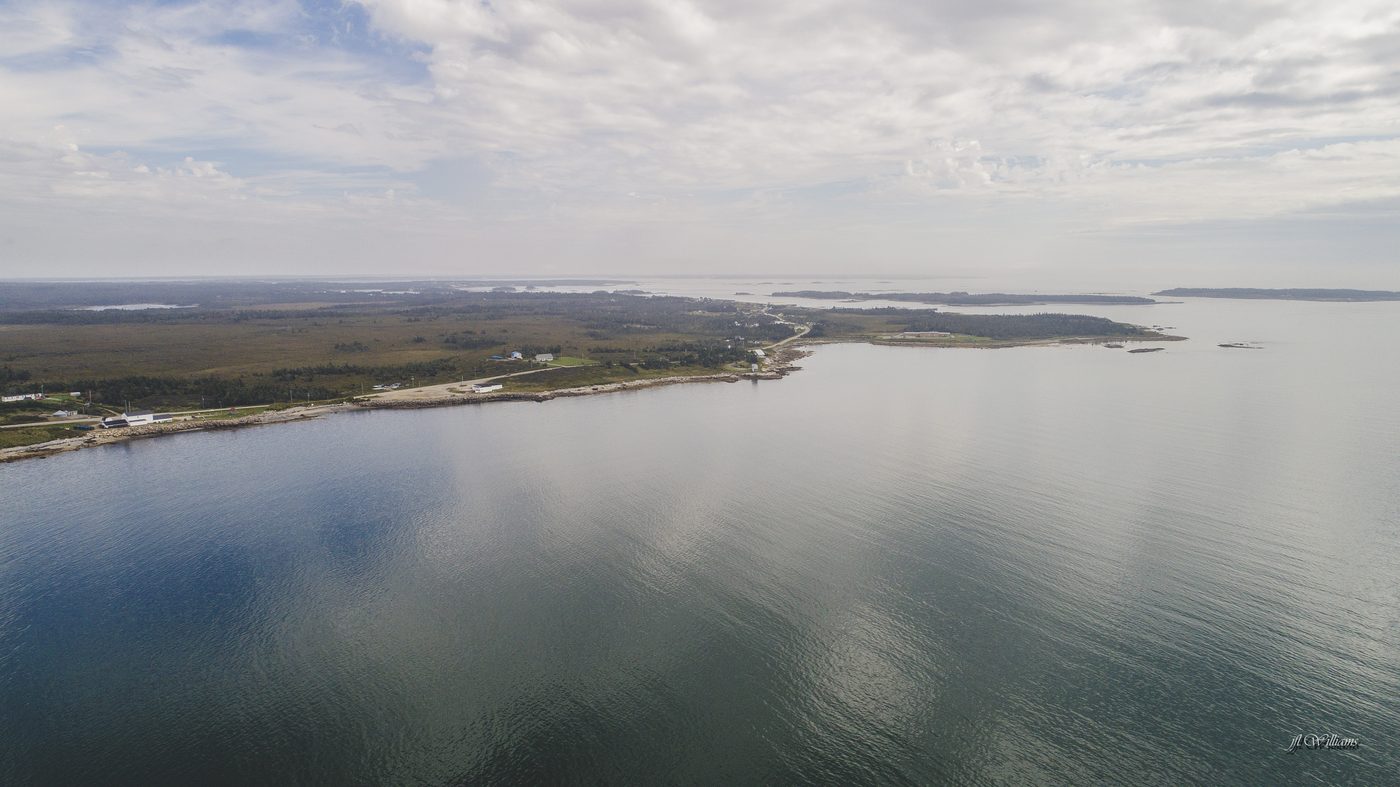
Shag Harbour from the air on a calm, cloudy day: a low wooded shore with a road and houses along it, and small islands off the point.
Shag Harbour from the air, 14 September 2017. Photograph: J5255, CC BY-SA 4.0, via Wikimedia Commons. Resized.
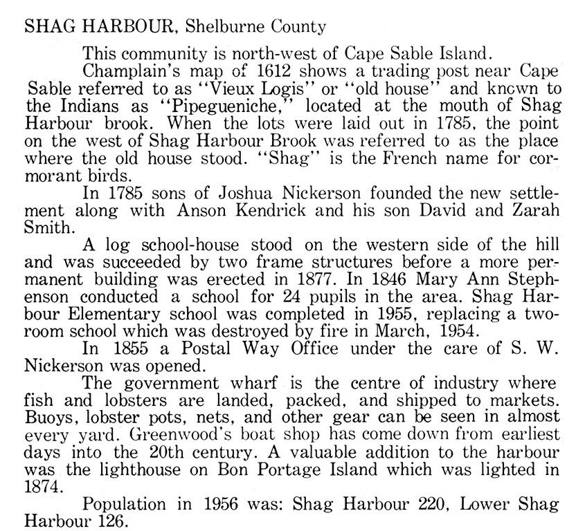
A printed book entry headed Shag Harbour, Shelburne County: the community is north-west of Cape Sable Island; the government wharf is the centre of industry, where fish and lobsters are landed; population in 1956, Shag Harbour 220, Lower Shag Harbour 126.
The village as the province's archives described it in the year of the incident, in the words of 1967. Public Archives of Nova Scotia, Place-Names and Places of Nova Scotia (1967), page 616. Nova Scotia Archives. Cropped to the entry.

↑ BACK TO TOP

04THE SEARCH

A lifeboat, the fishing boats
and seven Navy divers.

A corporal and two constables were at the shore within 15 to 20 minutes, in time to see the light. Constable Ron O'Brien told the Herald it was about a half mile off shore and was being carried out to sea by the tide. It was gone before a boat could reach it.

The RCMP called out Coast Guard lifeboat 101 from Clark's Harbour, and the local fishing boats joined it: six in one paper, eight in another. They found a wide patch of yellowish foam, 30 to 40 yd (27 to 37 m) across by one account and at least 80 ft (24 m) by another. They found nothing else. The other leads were checked that night, aircraft and flares among them, with no result.

The telex to Ottawa the next morning gave a position for the last sighting: 43°30.5′N, 65°45′W, "outside Lower Woods Harbour". That evening Canadian Forces Headquarters asked Maritime Command to investigate, and to consider an underwater search as soon as possible. A diving officer and three men were ordered to Clark's Harbour. The object, their orders said, was about 300 yards (270 m) off shore.

On 6 October Col. W.W. Turner, Director of Operations, put it in a memo. The Rescue Co-ordination Centre, he wrote, had "discounted the possibilities that the sighting was produced by an aircraft, flares, floats, or any other known objects". The divers started at noon that day. Three more came by helicopter on the 7th. By that evening the seven had searched an area half a mile by a mile and a half (0.9 by 2.8 km), in good conditions, and found nothing.

Maritime Command ended the search at 6:30 pm on Sunday, 8 October. A handwritten note in the file says it in four words: "terminated 08 Oct, NIL results". On 19 December headquarters wrote to two universities that the investigation "was terminated without conclusive findings". It was one of nine reports that year, of about 190, that headquarters had judged worth investigating.

All of this is from the papers themselves, in scans from Library and Archives Canada. The RCMP's own report is not among them.

Library and Archives Canada, RG 77, vols. 310 and 311: the Rescue Co-ordination Centre's telex (5 October 1967), Col. Turner's memo (6 October), Maritime Command's messages (5 to 8 October), a clipping of the Chronicle-Herald (7 October), headquarters' letters (19 December). The Condon Committee, Case 34, for the six boats and the 30 to 40 yd.

THE NIGHT AND THE WEEK, FROM THE PAPERS OF 1967

WhenWhat
4 Oct, 11:10 pmThe sighting, by the first report. The memo of 6 October has 11:45 pm
Within 15 to 20 minutesThree policemen at the shore; the light still on the water
That nightLifeboat 101 and the fishing boats; a patch of foam; nothing else
5 Oct, 9:15 amCutter 101 goes back with the RCMP on board
5 Oct, 10:20 amHalifax telexes the report to Ottawa
5 Oct, 6:20 pmOttawa asks Maritime Command to investigate
5 Oct, 7:50 pmA diving officer and three men are ordered to Clark's Harbour
6 OctCol. Turner's memo: not any known object. The divers start at noon
7 OctThree more divers by helicopter. Half a mile by a mile and a half searched by 7:30 pm
8 Oct, 6:30 pmSearch terminated. Nil results
19 DecHeadquarters: "terminated without conclusive findings"

The messages give Greenwich time. Nova Scotia was three hours behind it.

↑ BACK TO TOP

05THE SAME NIGHT AT SEA

Three red lights,
32 miles (59 km) south of Sambro.

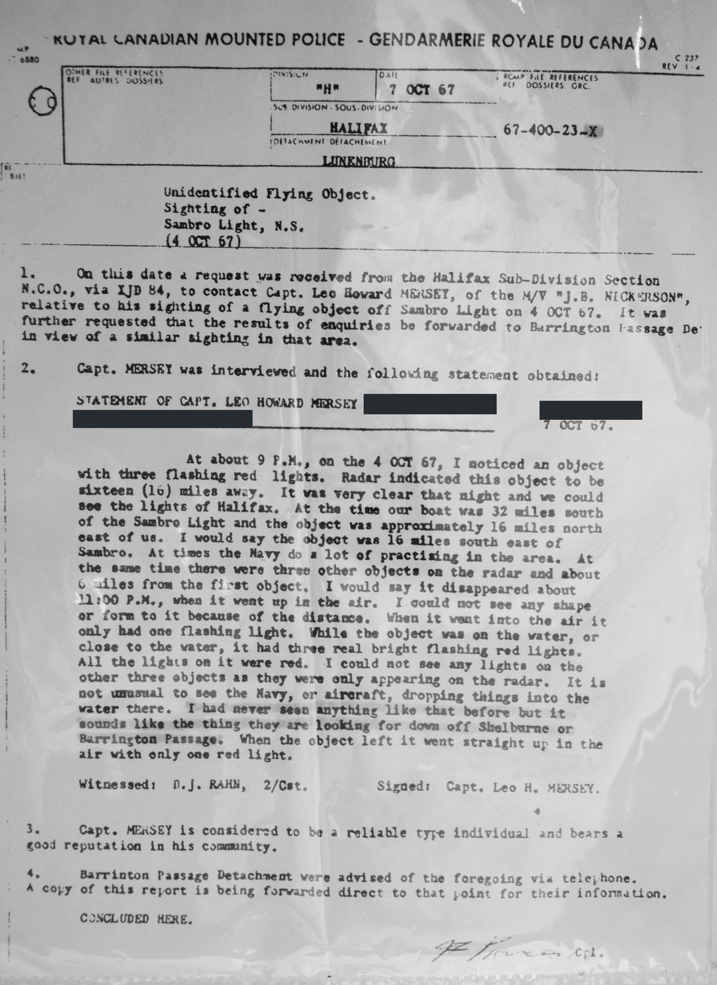
The same evening, about 200 km (125 miles) up the coast, a fishing captain saw lights of his own. Capt. Leo Howard Mersey of the M/V J.B. Nickerson was 32 miles (59 km) south of Sambro Light. About 9 pm he saw an object with three flashing red lights. His radar put it 16 miles (30 km) away, with three more objects about 6 miles (11 km) from the first.

About 11 pm, he said, it went straight up with one red light. He took the radar objects for naval vessels and the light for a helicopter, and thought no more of it until he heard the news on the radio. His statement adds: "It is not unusual to see the Navy, or aircraft, dropping things into the water there."

On 7 October the RCMP's Lunenburg detachment took that statement, file 67-400-23-X, and telephoned it to Barrington Passage because of the similar sighting there. It is the one police report of 1967 read in full for this page. It is not the report on Shag Harbour itself.

The University of Colorado's project spoke to the captain too. It put his objects about 175 nautical miles (324 km) from Shag Harbour and judged that the two events did not appear to be related. Placed from his own statement, the object is about 111 nautical miles (206 km) from Shag Harbour. The two figures do not agree.

RCMP "H" Division, report 67-400-23-X, 7 October 1967; the Condon Committee, Case 34. The statement does not name its mile; the page takes it as the nautical mile, 1.852 km.

A typed one-page RCMP report dated 7 October 1967, headed Unidentified Flying Object, Sighting of, Sambro Light, N.S., with the statement of Capt. Leo Howard Mersey. Three black bars cover personal details.
RCMP "H" Division, Lunenburg detachment, report 67-400-23-X, 7 October 1967. Royal Canadian Mounted Police, a microfilm copy held by Library and Archives Canada, via Wikimedia Commons; public domain. Three bars, added for this page, cover the captain's birth date and home community.

↑ BACK TO TOP

06HOW THE STORY GREW

What 1967 wrote down,
and what is told now.

The papers of 1967 hold more of the story than is often thought: the dark object, the four lights, the flash on the water, the half mile off shore, the dozen witnesses. A few things are not in them. Two can be measured, so here they are, drawn to scale.

THE FOAM, TO SCALE

Amber: the foam of 1967, a patch 30 to 40 yd (27 to 37 m) wide in the Colorado notes and "at least 80 feet" (24 m) in the Herald. No paper of 1967 gives a length or a count; three patches are drawn. Dashed: the strip told from 2008, about 80 ft wide and half a mile long (24 m by 800 m).

THE LIGHT, IN MINUTES FROM THE CALL

Amber: the Colorado notes of 1967: about 15 minutes until the police arrive (outline), then about five minutes more of light (solid). The first report says only "for long time". Dashed: watched for nearly an hour (Laurie Wickens to CTV Atlantic, 2019; The Walrus, 2016).

The papers of 1967 and the retelling
Papers of 1967Told later
Did it hit the water?Two answers. The first report: a bright flash on hitting the water. The Colorado notes: no one actually saw anything enter.A crash into the harbour, watched from the shore.
What it looked likeDark, more than 60 ft (18 m), four white lights about 15 ft (4.6 m) apart (the first report). Three or four yellow lights (the Colorado notes). Yellow and white, going on and off in turn (the Herald).An orange ball on the water. The size of a city bus.
How far off shoreAbout 300 yards (270 m), by the Navy's orders and the Colorado notes. About a half mile (800 m), by Constable O'Brien in the Herald.Half a mile.
The foamA wide patch: 30 to 40 yd (27 to 37 m), or at least 80 ft (24 m). No length.About 80 ft wide and half a mile long (24 m by 800 m). From 2008.
The light"For long time" (the first report). Police in about 15 minutes, then about five minutes more (the Colorado notes).Nearly an hour. From 2016 and 2019.
Who saw itA corporal and six other witnesses (the first report). Five young people first (the Colorado notes). At least a dozen (the Herald).At least eleven; about a dozen.
A second siteNone. Maritime Command's messages show one search, in one place, ended on 8 October.Under water to Government Point, about 25 miles (40 km). In print by 2001.
An explanationNone. Not any known object, by the memo of 6 October. "Without conclusive findings", by headquarters in December.Many, from a Soviet submarine to a craft from elsewhere.

So the retelling has added less than it may seem. The half mile off shore, the dozen witnesses and the lights going on and off are all in the Herald of 7 October 1967. What no paper of 1967 read for this page has is the foam's half-mile length, the hour, and the second site.

Papers of 1967: the Rescue Co-ordination Centre's telex, Col. Turner's memo, Maritime Command's messages and the Chronicle-Herald of 7 October (Library and Archives Canada); the Condon Committee, Case 34. Later accounts: The Coast (2008), the Canadian Press (2017 and 2019), Radio Canada International (2017), CTV Atlantic (2019), The Walrus (2016), CBC News (2026), Wikipedia.

↑ BACK TO TOP

07THE SECOND SITE

Government Point,
41.4 km (25.7 miles) away.

The story told today has a second half. After Shag Harbour, it says, the object moved under water about 25 miles (40 km) up the coast to Government Point, at the mouth of Shelburne Harbour. A second object joined it, naval ships watched for about a week, and then both left.

One part of that is on the record. There was a naval station at Government Point. HMCS Shelburne began work there on 1 April 1955, described as an oceanographic station. Its real work was listening for submarines, and that was made public in 1991.

The rest has no record of 1967 behind it that was read for this page. It comes from divers and former servicemen who are not named, as told to Chris Styles and Don Ledger, whose book Dark Object came out in 2001. The Canadian Press wrote in 2017 that there is "no hard evidence" for it. Maritime Command's own messages of that week, read for this page, show one search in one place, off Lower Woods Harbour, ended on 8 October with nil results. They name the station at Shelburne once: it was asked to give the divers logistic help if they needed it.

The distance is told three ways: about 25 miles, about 25 kilometres and about 50 kilometres. In a straight line between the province's official name points for the two places it is 41.4 km (25.7 miles).

The Municipality of Barrington's account; the Canadian Press (2017); The Coast (2008); Radio Canada International (2017) for 25 kilometres; Maritime Command's messages of 5 to 8 October 1967 (Library and Archives Canada); Wikipedia, "CFS Shelburne", for the station (one source; the Canadian Press says its purpose came out in the 1980s). The distance: GeoNAMES points.

THE SECOND SITE, SORTED

On the recordA naval station at Government Point from 1 April 1955
On the recordOne diving search, off Lower Woods Harbour, 6 to 8 October: nil results
On the recordThe station at Shelburne was asked to help the divers with supplies if needed
Told laterThe object moved under water to Government Point
Told laterA second object, a week's watch, and both gone
Not foundAny paper of 1967 that mentions it

↑ BACK TO TOP

08THE VILLAGE TODAY

A museum, a gazebo
and a coin that glows.

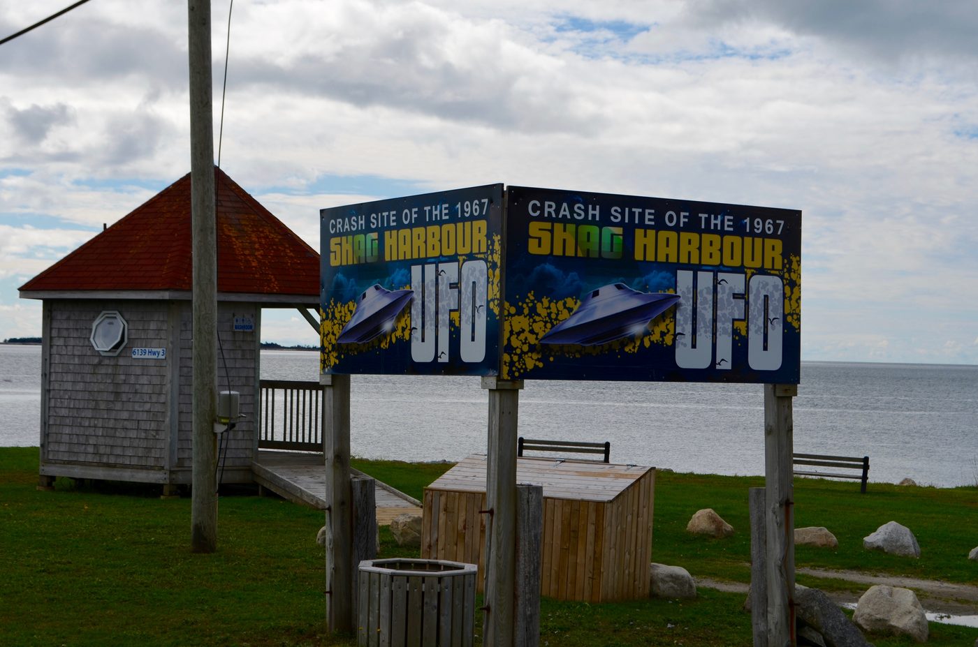
Shag Harbour keeps the story itself. The Shag Harbour Incident Society formed in the fall of 2006, by its own account, and opened a museum in a donated barn on 16 June 2007. Today it is the Shag Harbour UFO Centre at 5615 Highway 3. In 2026 it was open from 15 June to 4 October, 10 am to 5 pm. A gazebo and picnic site about three minutes up the road looks out over the water.

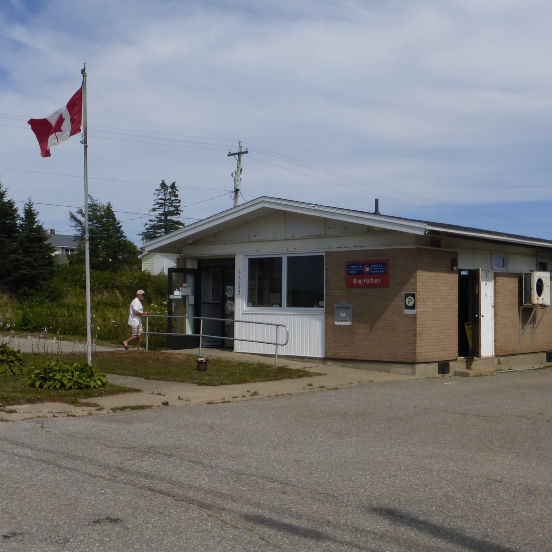
In 2017 the village marked the 50th anniversary with a three-day festival, and some events moved to Woods Harbour for the room. On 1 October 2019 the Royal Canadian Mint issued a coin of the incident that glows in the dark (section 09). The post office has had its own postmark for the incident.

Laurie Wickens, who made the call at 17, was deeply involved in his later years with the Society that runs the museum. He died in the summer of 2026, aged 76.

The 60th anniversary is 4 October 2027.

The Society's own pages, including its visitor information checked 13 October 2026; CBC News (2017, 2026); the Royal Canadian Mint and the Canadian Press (2019). The coin's design belongs to the Mint and is not shown.

A shingled gazebo with a red roof beside two painted signs reading Crash Site of the 1967 Shag Harbour UFO, on a lawn above the sea.
The gazebo and signs at the lookout, Shag Harbour, 30 September 2017. Photograph: SnowyBadger, CC BY-SA 4.0, via Wikimedia Commons. Resized. The sign's words are the village's; the 1967 record does not say "crash".
A small one-storey post office with a Canadian flag on a pole beside the road.
The post office at Shag Harbour, 6 August 2020. Photograph: Verne Equinox, CC BY-SA 4.0, via Wikimedia Commons. Resized.

↑ BACK TO TOP

09THE COIN

A coin that glows,
and the story it tells.

On 1 October 2019 the Royal Canadian Mint issued a coin of the incident: Canada's Unexplained Phenomena: The Shag Harbour Incident. It is a rectangular $20 coin of 1 oz (31.1 g) of 99.99 per cent pure silver, in a limited mintage of 4,000, at $129.95 each. By the end of its first day on sale, the Mint's website said 95 per cent had been sold. It was the second coin in the Mint's Unexplained Phenomena series, after a coin of the Falcon Lake encounter in Manitoba in April 2018.

The design is by the Canadian artist Pandora Young, who said she began by reading the eyewitness accounts. It shows three fishermen on a boat at night, looking up as a craft seems to plunge into the dark water near Shag Harbour. A black-light flashlight comes with the coin. Under its light the craft disappears, and four orange lights stay in the sky.

Laurie Wickens had contacted the Mint to say it needed a Shag Harbour coin. The Mint's page for the coin quotes him as an eyewitness and the president of the Society, and the Mint set aside a limited number to sell at the village's UFO festival that week.

The Mint tells it as a crash, and its picture has a flying saucer. The papers of 1967 give no shape. The table sets the coin beside them.

The Royal Canadian Mint: news release and the coin's own page, 1 October 2019. The Canadian Press, in CBC News, 1 October 2019. CBC News, 2 August 2026, for the call to the Mint (one source). The pictures are the Mint's own, shown with its credit.

Under black light the craft is gone, and four orange lights stay in the sky. Hover over the coin, or tap it, to see it in normal light. Image: Royal Canadian Mint.
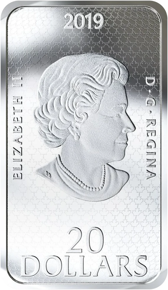
The back of the silver coin: Queen Elizabeth II in profile, the year 2019 at the top and 20 DOLLARS at the bottom.
The back: Queen Elizabeth II by Susanna Blunt, the year and the face value. Image: Royal Canadian Mint.
The coin of 2019 and the papers of 1967
The coin, 2019Papers of 1967
Did it hit the water?A craft going down into the water; the Mint calls it a crash.Two answers. The first report: a bright flash on hitting the water. The Colorado notes: apparently no one actually saw anything enter.
Its shapeA flying saucer.None given. A dark object, more than 60 ft (18 m), in the first report.
The lightsFour orange lights, under black light.Four white lights about 15 ft (4.6 m) apart (the first report). Three or four yellow (the Colorado notes). Yellow and white (the Herald).
Who is watchingThree fishermen on a boat.Five young people in a car called first; a corporal and six other witnesses; fishing boats went out to the light.
When the search endedCalled off on 9 October, on the Mint's page.Maritime Command: terminated at 6:30 pm on 8 October, with nothing found.

↑ BACK TO TOP

10WHAT IS NOT KNOWN

Where the record
runs out.

↑ BACK TO TOP

11READING THIS PAGE

The papers first,
the retelling marked.

The story is sorted by the kind of record behind each moment. A solid amber dot is a paper of 1967 that was read for this page: the Rescue Co-ordination Centre's telex, Col. Turner's memo, Maritime Command's messages, a clipping of the Chronicle-Herald, headquarters' briefing and letters, the University of Colorado's telephone notes and one RCMP report. A half dot is a paper of 1967 that was not read, known from a later description. A hollow grey-blue dot was told later.

On the map, what a paper of 1967 says is solid and amber. What was told later is dashed and grey-blue, with its year. Where the papers of 1967 disagree, the page shows both. It takes no side on what the light was.

Places: towns and points are the province's official name points. The last sighting of the light is the position printed in the telex of 5 October 1967, with a dashed box for the half minute it is given to. The boat and the object at sea are placed from the captain's statement. Where the boats, the foam and the divers' area lay is not recorded. The shoreline is today's.

Read the data method ↗

↑ BACK TO TOP